Type Of Clouds Considered Most Dangerous To Aircraft Midair
In flight, pilots pay attention to weather patterns while navigating the airspace of various regions, or countries...

Whenever an aircraft flies from one destination to another, no matter how short or long, the aspect of weather is considered one of the most important in aviation.
In flight, pilots pay attention to weather patterns while navigating the airspace of various regions, or countries and any change in such patterns could mean a lot in terms of safety during flights.


There are two kinds of weather patterns, as explained by Kenya Airways (KQ) captain Ruth Karauri, who in February 2022 heroically battled the elements of a weather storm to land at Heathrow Airport in the United Kingdom (UK).
"This term is used in aviation to mean either of 2 things. On the ground, it will be in reference to atmospheric conditions while in the air it will be referencing cloud build-up. Today we will cover the air bit and talk about the ground next time," she wrote on Twitter.
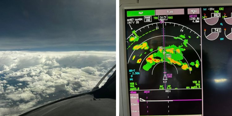
A collage of a plane flying above the clouds and an instrument showing cloud cover while airborne. /TWITTER.RUTH KARAURI
She further noted that a majority of modern-day aircraft come with pre-installed weather radar systems that alert pilots regarding cloud activity mid-air and along, or around their flight path.
According to her, pilots would inform Air Traffic Control (ATC) of the intention to avoid weather as they are going around a cloud build-up, normally as a result of clouds forming when moist air is cooled to such an extent that it becomes saturated. The main mechanism for cooling air is forcing it to rise.
"So when airborne, pilots will usually tell ATC that they’re avoiding weather. This essentially means they are going around a cloud build-up.
"Most planes are equipped with weather radar which gives information to the pilots about cloud activity on and around the flight path," she added.
Many must be wondering which type of clouds pilots avoid despite the fact that aircraft fly through and above the clouds to their destination. Avoiding storms and obviously hazardous weather is usually pretty easy for even the new pilot, but what about the weather that appears safe but might be hiding more dangerous features than what meets the eye?
This is where Cumulonimbus clouds come in, considered terrifying to people on the ground and pilots in the air. These are considered the biggest clouds in the sky and are associated with strong to even severe weather ranging from heavy rain to strong updrafts and downdrafts to cyclones.
The defining characteristics of a cumulonimbus cloud, a towering column-like structure and falling precipitation, are indicators that hazardous conditions exist in and around the cloud. These clouds are most often associated with convective thunderstorm activity and occur in isolation, as part of squall lines, or as embedded thunderstorms.
The most visually obvious hazard associated with cumulonimbus clouds is heavy rain. By definition, this rain falls from the cloud base and may become extreme.
Severe thunderstorms along squall lines may produce rainfall rates of greater than 2 inches (5.08cm) of rain per hour. Extreme precipitation rates like this may be sufficient to flood pitot-static systems and overwhelm piston engine induction systems as well as force turbine engines into failure.
The large vertical development of a cumulonimbus cloud is the tell-tale sign of strong updrafts pulling moisture upward. Meanwhile, the presence of rain indicates that strong downdrafts have developed within the cloud; as these updrafts and downdrafts mix they produce extreme turbulence that may occur suddenly, posing the risk of structural damage to aircraft operating above their manoeuvre speed or turbulence penetration speed.
These updrafts and downdrafts and their associated turbulence may result in difficulty in maintaining altitude, airspeed, and attitude control of the aircraft. Even for aircraft passing below the cloud, these vertical wind currents pose a significant hazard.
Another cumulonimbus hazard associated with strong turbulence, updrafts and downdrafts is lightning, a mixing of air, dust and water molecules resulting in the build-up of electrical fields within the cloud itself, which is ultimately discharged in often spectacular form. Lighting is often a good visual clue of both the strength of the updrafts and the downdrafts within a cumulonimbus cloud.
While lighting does not pose a direct hazard to pilots or passengers within an aircraft, the side effects of a lightning strike on crew members and aircraft systems are significant.
Crew members may suffer visual impairment and disorientation immediately following a lightning strike, these hazards are of particular concern at night while in instrument meteorological conditions (IMC), as the crew will likely suffer a loss of night vision and subsequently risk difficulty maintaining a sufficient instrument scan.
The aircraft may also suffer damage to electrical equipment, including damage to communication and navigation radios, avionics equipment, or to other aircraft systems. The build-up of static charge on the aircraft in a lightning-prone environment may also block radio communications with other aircraft and Air Traffic Control.
"In the most simple terms, weather radar will use radio waves to detect the intensity and movement of water droplets that are present in clouds. It will then display this information to the pilots in a colour-coded display and will aid them in determining the best course of action.
"The most intense areas are displayed in red, lesser intensity in amber and the lowest is green. Red and amber areas are always avoided but we may sometimes fly through the green areas with minimal discomfort to the passengers and crew," Karauri added.
The simplest answer to minimizing exposure to the dangers of cumulonimbus clouds is to avoid them altogether. When airborne, if a flight crew identifies an area of cumulonimbus development; the selection of an alternate route is the best initial plan of action.
In general, it is best to remain on the upwind side of a cumulonimbus cloud and to remain clear of it by at least 20 nautical miles (37.04 km).
"During preflight planning, it is important to consider where cumulonimbus clouds may form. Because cumulonimbus clouds feed on atmospheric instability, expect to see them where unstable conditions prevail. High humidity, high-temperature lapse rates, warm temperatures, and atmospheric or geographic lifting actions will all tend to trigger cumulonimbus cloud development.
"Cumulonimbus development may occur as distinct, isolated showers and storms, or may develop, under the right conditions, into a line of powerful severe storms. Isolated cumulonimbus clouds are likely to occur as a result of convective heating and sufficient atmospheric moisture," explains in part an article by Airplane Academy.
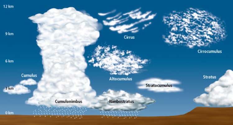
An image of the types of clouds in a plane's flight path. /NATIONAL WEATHER SERVICE
Larger storm systems that form along the boundaries of low-pressure systems likely include embedded cumulonimbus clouds that are all but invisible to pilots. These systems result in complex storm dynamics that present a wide mix of hazards; it is best to avoid these areas as the pilot’s greatest tool for identification of cumulonimbus cloud formations will be obscured by instrument meteorological conditions.
Pilots should consider cumulonimbus clouds as being synonymous with thunderstorms. The primary goal should be avoidance of these areas and the associated hazards, as any of the hazards associated with cumulonimbus cloud development may overwhelm the ability of a flight crew or aircraft to successfully transit a cumulonimbus cloud.
Simply put, a cumulonimbus cloud that seems to be “not that bad” may very quickly become significantly dangerous.


